In the Valley, eight people were arrested for non-violent civil disobedience and 184 acres of land were permanently protected from development. On June 24, eight people were arrested while protesting the construction of a fracked gas pipeline in Sandisfield, Massachusetts. Sandisfield is in the Connecticut river valley, about an hour by car west of Springfield.
Police arrested Eric Burcross from Plainfield, Massachusetts; Dennis Carr from Cummington, Massachusetts; Northampton residents Francis Crowe and Constance Harvard; Ellen Graves from West Springfield, Massachusetts; Priscilla Lynch from Conway, Massachusetts; Elizabeth Ramirez from Holyoke; and Laura Simon from Wilder, Vermont.
The activists have a web site at www.SugarShackAlliance.org.
On June 23, the mayor of Northampton announced the city had permanently protected 114 acres of open space from development.
On the same day, in Putney, Vermont, near Brattleboro, a nature preserve that extends into other nearby towns was expanded by 70 acres. More information is at www.WindmillHillPinnacle.org.
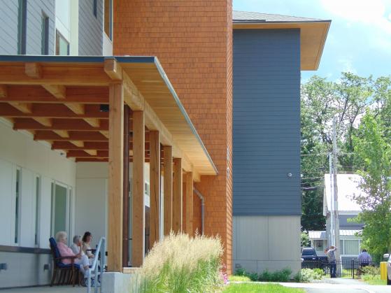
New homes can be built without destroying open space by converting run-down, one-story, drafty single family houses to two or three story, energy efficient buildings that contain several apartments. Last month in Brattleboro, the first people moved into a new apartment building on Fairground Road. The below photo, taken on June 25, shows the building. To enlarge the photo, click on it, then scroll down and click “see full size image.” photo by Eesha Williams
The below map of the Connecticut River watershed in Massachusetts, southeast Vermont and southwest New Hampshire shows that the vast majority of the farmland and forestland is vulnerable to being converted to houses, roads, parking lots, and Walmart stores and similar commercial buildings. The map was current as of 2015.
Click on the map to enlarge it, then scroll down and click "see full size image." Then click on the map again to enlarge it more. You can move the image using the arrows on your keyboard.
For a sense of scale, Pisgah state park can be seen on the map. Is is the biggest protected area that is both east of Brattleboro and southwest of Keene. It is about 13,300 acres.
_0.img_assist_custom-171x205.png)
Post new comment